 Revised SOLAS Radiocommunications GMDSS Requirements 16.03.2024 00:39
A revised SOLAS Chapter IV containing requirements for radiocommunications applies to new and existing ships on or after 1 January 2024.
This has been published by the IMO as Resolution MSC.496(105). It has also published guidelines in COMSAR.1/Circ.32/Rev.2 – Harmonisation of GMDSS Requirements for Radio Installations On Board SOLAS Ships, which will also take effect on 1 January 2024.
The amendments to SOLAS Chapter IV have the following major consequences:
• For ships operating in sea areas A3 or A4, HF direct-printing telegraphy (NBDP) is no longer required for transmission and reception of distress and safety radiocommunications. However, shipowners may choose to retain HF NBDP equipment for reception of maritime safety information (MSI).
• NAVTEX, EGC and HF NBDP receivers will no longer be mandatory. The amended Regulation IV/7.1.1.4 states that “every ship shall be provided with a receiver or receivers capable of receiving MSI and search and rescue related information throughout the entire voyage in which the ship is engaged”. Operators will need to decide what equipment is needed, depending on the ships trading pattern. IMO circular MSC.1/Circ.1645 gives guidance on choosing equipment to meet the new requirement.
The SOLAS amendments have moved the requirements for carrying two-way VHF radiotelephone apparatus and search and rescue transponders (SARTs) from SOLAS Chapter III to Chapter IV. This change has necessitated some amendments to the wording of the related SOLAS certificates. The changes also affect certificates related to the SPS Codes, HSC Codes and MODU Codes.
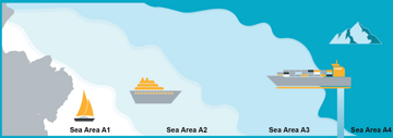
The definition of Sea Area A3 has changed as follows:
• “Sea area A3 means an area, excluding sea areas A1 and A2, within the coverage of a recognised mobile satellite service supported by the ship earth station (SES) carried on board, in which continuous alerting is available”.
This means Sea Area A3 is dependent on the particular recognised satellite service (RMSS) SES equipment installed on the ship. For example, for a ship provided with Inmarsat SES, Sea Area A3 for that ship will be roughly from 70°S to 70°N (i.e. the coverage area for the Inmarsat satellite system). For a ship provided with Iridium SES, Sea Area A3 for that ship would be the entire globe. Where two SES are installed, the SES with the lesser coverage will determine the coverage of the ship.
VHF emergency position indicating radio beacons (EPIRBs), which are not widely used, are no longer acceptable for GMDSS purposes. (This is currently only an option for ships certified for Sea Area A1 alone.) They will need to be replaced with other acceptable equipment, such as a satellite EPIRB.


