
 EMSA starts using drones 30.04.2022 12:17
The European Maritime Safety Agency (EMSA) starts Emissions monitoring campaign over the Baltic Sea using drones.

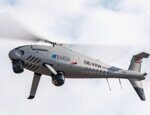
EMSA is conducting a large-scale emissions monitoring campaign using remotely piloted aircraft, scheduled to begin later this month. Over a three-month period, a specially equipped drone will measure the sulphur content in the exhaust plumes of ships transiting the Baltic Sea in order to be able to detect violations of the applicable limits. At the same time, image data will also be collected for hydrographic surveying purposes.
The remotely piloted aircraft will take off from the German Armed Forces' Staberhuk site on the east coast of Fehmarn and fly over selected ships operating in the Fehmarn Belt and the Kadetrinne/Kadetrenden in order to measure the sulphur content of their exhaust plumes using specific sensors. In this way, it will be possible to infer the sulphur content of the ship’s fuel, which must not exceed a level of 0.10% in the Baltic Sea Emission Control Area (SECA).

The measurement results are made available in real time to responsible authorities in all European ports via THETIS-EU, the Port State Control information system operated by EMSA. In this way, ships can be specifically selected for inspection at their next port of call and samples of the fuel can be taken. If violations of the strict sulphur limits can be proven, those responsible face heavy penalties.
In addition to ship exhaust gas measurements, multispectral aerial imagery is acquired. For shallow waters, bathymetric values can be extracted from images. Furthermore, imagery allows for three-dimensional mapping of the shore zone. The drone survey campaign will investigate whether aerial imagery can provide complementary information for the German hydrographic surveying service. The drone flights are operated by the Norwegian company Nordic Unmanned on behalf of EMSA. The sensor technology and analysis capabilities for the emission measurements is supplied by the Danish company Explicit ApS.
Remotely Piloted Aircraft System (RPAS) services are offered free of charge to all EU countries by EMSA. They have been developed to assist in maritime surveillance operations and ship emission monitoring and can operate in all seas surrounding the European Union. RPAS services can provide support to traditional coast guard functions, including search and rescue and pollution prevention and response. The services are offered to member countries individually and as part of EMSA’s regional RPAS strategy, which allows multiple coast guard functions in several EU countries to be supported by one or more RPAS services.

